Kintampo Waterfall
Ghana |

Location Guide |
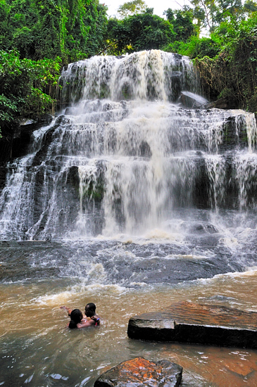
This is a series of 3 waterfalls, the largest
being 25m high. In total, in a number of steps and cascades, the river drops 70m.
| In colonial days this was known as Sanders
Falls, it is located on the river Pumpum, a tributary of the Black Volta. People can go into the pool under the
waterfall, and I saw 3 in the water while I was there.
On entry a guide takes you first up to
the top falls, which can be photographed, then the the centre falls that are
difficult to see and finally down to the far larger bottom one. There is a climb of 152 steps back to the car park level.
This concrete stairway was added
in the mid 1960's.
There is an archaeological site at/or near Kintampo, where civilisation can be shown to have existed between 2500BCE and
1400BCE, and it's the earliest known site for the cultivation of the cowpea.
These were farmers with stone buildings as wattle and daube, using
polished stone axes and stone beads, domestic pots, ceramic sculptures of people
and more.
We have a fuller and more
varied set of photographs in the
Kintampo Waterfall
Photo Gallery

 |
 |
|
Location: Kintampo Waterfall, Ghana |
|
map Reference: 8.05 north lat and 1.705 w long |
Country/region: Ghana |
|
Map Link:
|
Aerial photo: |
|
Getting there: |
|
Access: Off the road from Kumasi to Mole
National Park, 5km north of Kintampo off the Tamale road. |
|
Website: |
|
Other Useful Websites: |
|
Email: |
|
Address: |
|
Postcode: |
Telephone: |
|
Opening Times: |
|
Charges: 3 GHS including local guide |
|
Nearby Locations: There is a smaller waterfall
nearby, known as Fuller Falls, near the village of Yabraso, 8km from
Kintampo on a road to New Longoro, on the Yoko river, with a 10m upper fall,
that is said to be pretty, and a pool below that is safe to swim in, at one
point the water disappears underground for about 40m.
Kintampo was the geographic centre of the Gold
Coast, (Ghana when it was British controlled).
Another tourist attraction is the Pinihini
Amovi Caves which are located near Fiema. These are underground caves and
history has it that some Akans migrated from these underground
caves. Visitors are however, cautioned that only the traditional priest of
Pinihini can lead them to the cave site. |
|
Other Location Pages:
Kintampo
Waterfall Photo Gallery
|
|
Notes:
|
|
Page Ref: kintampo_waterfall |
Classification: Landscape |
Date Updated: 01/2009 |
|
|
Please let us know any other information that we
can add to the Grid(s) or page and any errors that you discover. Before making a long trip to any location it is always
wise to double check the current information, websites like magazines may be
correct at the time the information is written, but things change and it is of
course impossible to double check all entries on a regular basis. If you have
any good photographs that you feel would improve the illustration of this page
then please let us have copies. In referring to this page it is helpful if you
quote both the Page Ref and Classification from the Grids above. To print the
planning grid select it then right click and print the selected area.
Please submit information on locations you discover so
that this system continues to grow.
|